About the Products

This method section is the equivalent to a preprint for the talk I am giving at the Weather and Forecasting Conference, during the AMS meeting in Phoenix. The title for that talk is:
Real-Time Piecewise Potential Vorticity Inversion:
Methodology, Preliminary Results and Potential Applications

by Sebastien Korner and Jonathan Martin
Today I'm going to talk about some exciting work that Jon Martin and I have been doing at the University of Wisconsin - Madison. It has to do with performing real-time potential vorticity inversion and making the results available to everyone on a daily basis. There are some very good reasons for wanting to do this.
Mid-latitude weather systems are characterized by complex interactions among multiple layers of the atmosphere. Employment of what could be called the "basic state variables" approach in which temperature advection, divergence, vorticity, and omega are explicitly examined, provides one method for understanding and predicting the structure and evolution of these systems. This approach, however, offers a limited capacity to describe the interactions occurring among the significant layers of the atmosphere. Recently, mid-latitude weather systems, especially cyclones, have been investigated through the lens of potential vorticity analysis. This perspective, in which significant elements of the balanced dynamics of cyclones can be regarded in terms of a single scalar variable, has led to new insights regarding the nature of interactions among layers. These insights have primarily helped to increase our understanding of the cyclogenesis process and the role of latent heating in cyclone evolution. The investigations though, have been limited to historical case studies. We feel that the full impact of the power of potential vorticity thinking cannot be realized until one has daily access to real-time inversion results. This access would provide the opportunity to become familiar with the wide range of interactions possible in cyclones, as well as the methods used to display the interactions. For this reason we have recently begun performing daily PV inversions, making the results available to anyone with access to the World Wide Web.
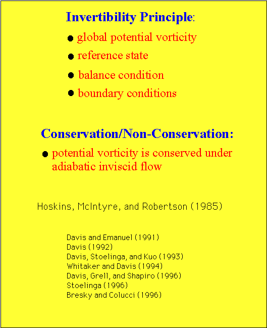
The power of potential vorticity thinking is based on the invertibility principle and the conservation or non-conservation of potential vorticity. The invertibility principle states that, given a distribution of potential vorticity throughout a domain, a specified reference state, an appropriate balance condition, and suitable boundary conditions one can recover the balanced mass and momentum fields throughout the domain. By conservation or non-conservation I am referring to the fact that potential vorticity is conserved under adiabatic inviscid flow. This property allows confident and quantitative identification of regions away from the surface where diabatic processes are occurring. These two topics, along with many others relating to PV thinking, are discussed in detail in the 1985 paper by Hoskins, McIntyre, and Robertson. All of the people in the reference list have successfully applied the ideas in this 1985 paper.
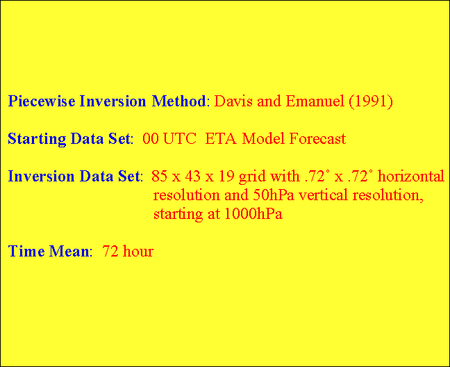
Inverting the PV for the entire atmosphere is interesting, but a more insightful diagnostic technique is piecewise potential vorticity inversion. This involves dividing the atmosphere into significant layers and independently inverting the PV in those layers. The beauty of this technique is that it allows for analysis of the influence of discreet portions of the total PV field on the flow throughout the domain. The piecewise inversion method we are using is that developed by Davis and Emanuel. A complete explanation of their method is given in their 1991 MWR publication.
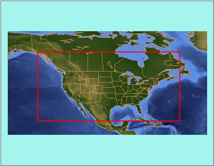
The inversion cannot occur without a data set. Our inversion is only run once a day, at 00Z, and the starting data set is the 00Z ETA model forecast for that day. An 79x39 subset with 1.0 degree by 1.0 degree resolution is then extracted, and 19 levels are used from 1000mb to 100mb every, 50mb. Here is a picture of the horizontal domain. If you recall from the invertibility principle, we also need a reference state. In an attempt to minimize the dependency on old data without compromising results, we have chosen a 72 hour time mean as the reference state. The 72 hours include the current 48-hour forecast plus the first 24 hours of the previous 00Z ETA model run. Our experience suggests 72 hours is long enough to isolate most features of interest except in episodes characterized by stationary longwave features.
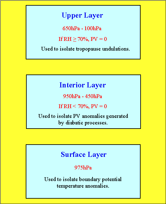
Effective use of piecewise potential vorticity inversion requires a meaningful partitioning (this figure has an incorrect depiction of the surface layer) of the atmosphere. The goal is to account for nearly all of the perturbation PV, while not inverting any of it more than once, which is accomplished by grouping together PV anomalies with a common history. Thus, we have adopted a conventional three-way partitioning, introduced by Davis and Emanuel, resulting in an upper layer, an interior layer, and a surface layer. The upper layer consists of the levels from 650mb to 100mb. As the main function of this layer is to isolate potential vorticity anomalies associated with undulations in the tropopause, the PV in this layer is set to 0.01 PVU where the RH >= 70%. The interior layer consists of the levels from 950mb to 450mb. The main function of this layer is to isolate PV anomalies associated with diabatic processes. To accomplish this the PV in the interior is set to 0.01 PVU where the RH < 70%. The surface layer is the 975mb potential temperature, which is obtained from the 1000 and 950mb theta fields, and the levels from 950mb to 850mb. This layer is used to isolate boundary potential temperature anomalies, which Bretherton proved are equivalent to potential vorticity anomalies just above the surface, and any low level positive PV perturbation not in saturated air. Thus, the PV in the 950-850mb layer is set to 0.01 PVU where the RH >= 70%.
The overlap between the upper and interior layers does not lead to PV being inverted twice, because of the RH criteria. Extensive three dimensional visual analysis was performed to verify the effectiveness of the 70% criteria. Never was it obserevd that PV anomalies were removed from their correct grouping (based on origin) because the RH category changed over time. If the RH criteria had been higher than 70%, this could have been a problem. Thus, the only perturbation PV not inverted is that which exists in unsaturated air in the 800-700mb layer and in saturated air in the 400-100mb layer. The aforementioned visualization studies also confirmed that there is an insignificant amount of PV that falls into this category.
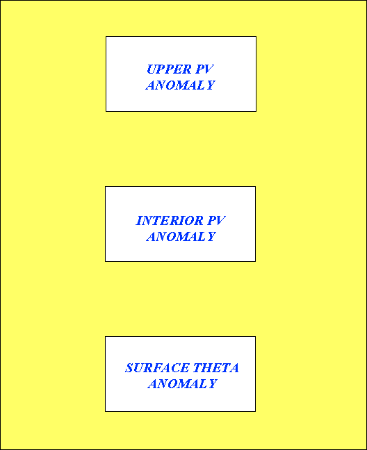
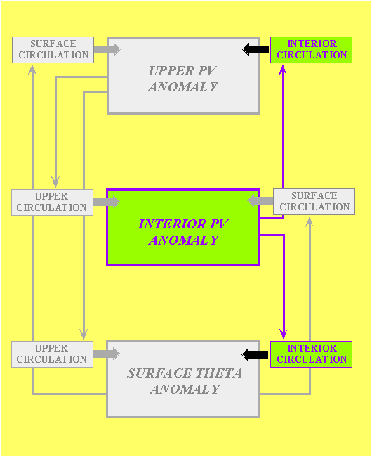
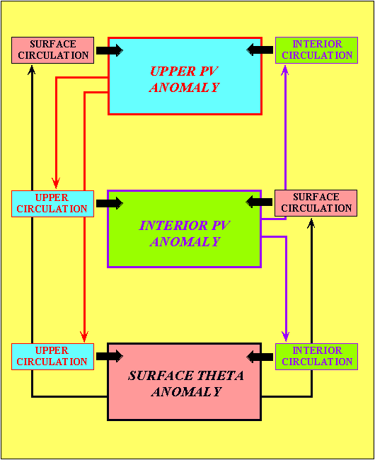
Now we must address the issue of what to do with the results of a successful inversion. We feel that, most likely, new insights will arise from considering the interaction of PV anomalies at different levels. This interaction can lead to intensification, destruction, restructuring, and advection of the various anomalies. Our partitioning method allows us to study the interactions between the three layers just discussed.
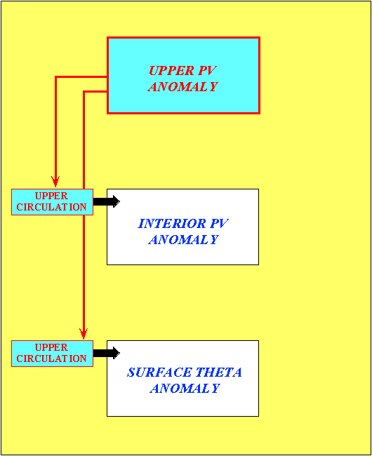
Let's first look at the potential influences of an upper anomaly. If it's circulation is capable of penetrating to the surface layer that circulation can influence the intensity and propagation of a surface anomaly. This basically involves affecting the amplitude of the surface wave and advecting it. Recall that penetration depth is proportional to the length scale of the anomaly but inversely proportional to static stability. One example of the upper level influencing the surface occurs when an upper trough approaches a surface baroclinic zone and initiates cyclogenesis; the classic Petterssen Type B development. The flow associated with an upper anomaly can also influence anomalies in the interior layer as well as those in the upper layer. This influence is primarily in the form of redistribution by advection.
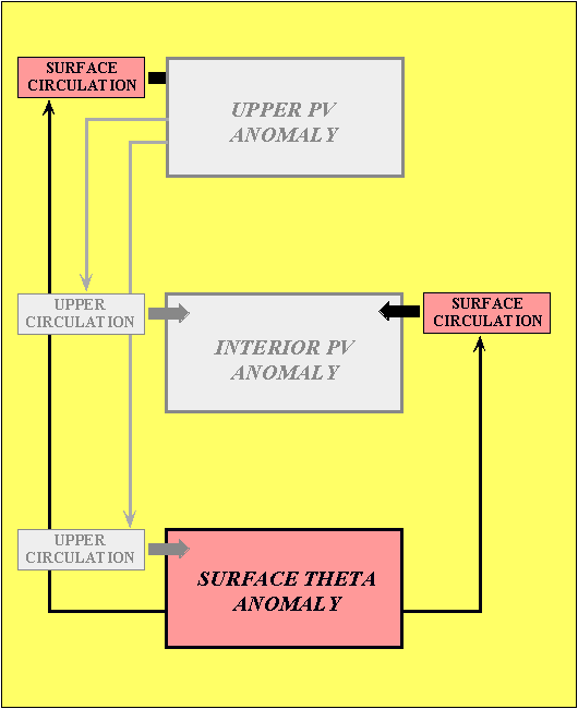
The winds associated with an anomaly located in the surface layer have the potential to influence anomalies in the interior and upper layers, as well as in the surface layer. If the surface based circulation is able to penetrate to either remote layer it can rearrange or intensify anomalies located there. We now have enough information to describe the baroclinic instability process from a PV perspective, in the manner of HMR. If the winds associated with a surface anomaly can penetrate to the upper layer and winds associated with an upper anomaly can penetrate to the surface, then the potential exists for phase locking and mutual intensification. The potential will be realized if the anomalies are aligned so that each anomaly's associated winds are retarding the propagation of the other anomaly, as well as providing an amplifying effect. This does not even consider the the effects of circulations associated with interior anomalies that are certainly acting at the same time!
The interior layer is no different from the other layers. The winds associated with an anomaly in this layer can influence anomalies in the upper and surface layers, as well as anomalies at mid-levels. The influence will again be in the form of amplitude modulation and redistribution by advection.
So you can see that there are a wide variety of potential interactions, but it is important to remember two things. The interactions may not all be significant at once, and when one anomaly alters another anomaly the nature of the affected anomaly's interactions with others may change. Thus the cycle of interaction begins again with the altered anomalies.
The best way to look for and study these complex interactions is to plot the winds obtained from the inversion of each layer on top of potential temperature at levels that represent the three layers. These are the types of products we have on our web page, and now I will show you some examples of the use of these products.
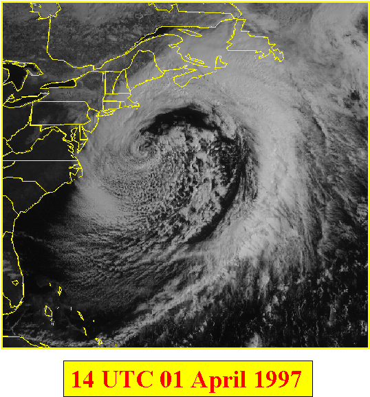
I brought with me some current slides from the web page, but the examples I have chosen to show are from around the 1st of April, 1997. Here is a visible satellite image from 14Z on the 1st of April. This record breaking storm brought heavy snow to Southern New England and high winds all along the northeast coast. It's structure is characterized by an intense upper level potential vorticity anomaly, a strong interior PV anomaly associated with the intense precipitation, and a distinct surface thermal wave.
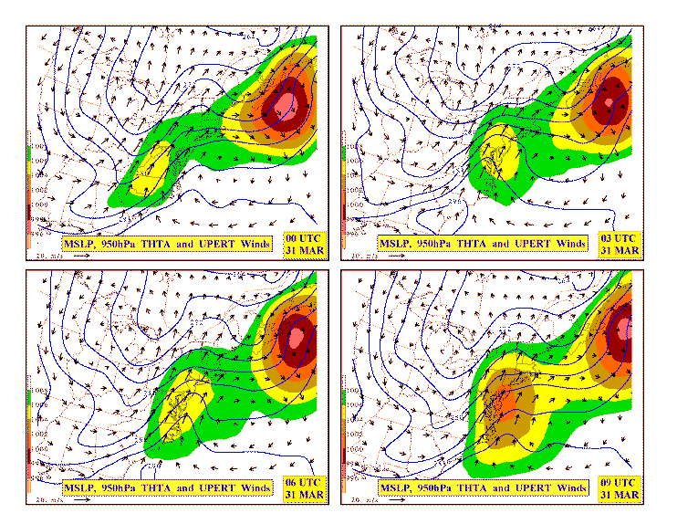
This figure (better looking postscript file) contains the winds associated with the upper layer PV anomaly on top of 950mb potential temperature contours, along with filled contours of mean sea level pressure, for 00Z - 09Z on March 31st; the early stages of cyclogenesis. There are several interesting features that jump off this map. First of all, the cyclonic circulation from the upper anomaly is clearly visible (over Milwaukee at 00 UTC). Also, note that there are at least two thermal waves along the east coast (one north of New York state and one just off the North Carolina coast). The southernmost wave is the one that develops into the dominant feature in about 24 hours. From the inversion point of view the most interesting feature here is the effect the winds associated with the upper anomaly are having on the propagation and development of this wave. For all nine hours the axis of maximum winds is just upstream of the axis of maximum theta, which means the upper anomaly is holding back the surface wave while slightly amplifying it. This can be seen in the pressure field, as the cyclone center barely moves and slowly deepens over the nine hours. Soon the upper anomaly will be in a more favorable position for amplifying the wave and rapid cyclogenesis will ensue. This is merely one of the dozens of standard inversion maps that could be plotted for this case, but there is more that can be done with inversion results than just looking at interactions. One can look at the kinematic properties of the wind field, such as divergence, deformation, and frontogenesis.
This figure (better looking postscript file) contains the positive frontogenesis occurring as a result of the winds associated with the upper anomaly acting on the 950mb theta field (upper two panels) and the winds associated with the surface anomaly itself acting on the same field (lower two panels), for 00z and 03z on March 31; again, at the earliest stages of cyclogenesis. This is not the total frontogenesis, but it does allow one to observe the contributions to the total resulting from circulations based at the levels. Note the positive frontogenesis by the winds associated with the upper anomaly occurring already at 00z. If we look back at the previous slide, we see that this is not that unexpected. On the bottom half of this figure, note the positive frontogenesis along parts of the warm and cold fronts, occurring as a result of the surface anomaly's wind field. This is fascinating, because it hints at the possibiltiy of self-amplification, at least in terms of frontal intensity. Later on in the life of this storm the interior PV anomaly will also become an important contributor to the total frontogenesis.
We feel that there is a place for real-time PV inversion in the life of a research meteorologist as well as an operational meteorologist. Both may benefit from an increased understanding of how the complex interactions of the atmosphere are working to create and destroy weather systems. This increased understanding may provide new insights into research questions, as well as open up some new research avenues, and it adds a new tool to the analysis arsenal of the operational meteorologist. Perhaps PV inversion can even be used directly as a forecasting tool. We are not sure what we will discover through the use of daily inversion since it is so new, but we are beginning to evaluate its usefulness as we integrate it into our set of daily forecasting and analysis tools at Wisconsin. We encourage you to come to the web page and look at the products every day. Make suggestions about how we can improve them and what new products you might like to see. Some future plans for the page include expanding the grid or perhaps having more than one grid, running a 12Z inversion, and expanding the selection of products.
Bresky, W. C., and S. J. Colucci, 1996: A forecast and analyzed
cyclogenesis event diagnosed with potential vorticity.
Mon. Wea. Rev., 124, 2227-2244.
Davis, C. A., 1992: A potential vorticity diagnosis of the
importance of initial structure and condensational heating in
observed extratropical cyclogenesis. Mon. Wea. Rev., 120, 2409-2428.
Davis, C. A., and K. A. Emanuel, 1991: Potential vorticity
diagnostics of cyclogenesis. Mon. Wea. Rev., 119, 1929-1953.
Davis, C. A., E. D. Grell, and M. A. Shapiro, 1996: The balanced
dynamical nature of a rapidly intensifying oceanic cyclone.
Mon. Wea. Rev., 124, 3-26.
Davis, C. A., M. T. Stoelinga, and Y.-H. Kuo, 1993: The integrated
effect of condensation in numerical simulations of extratropical
cyclogenesis. Mon. Wea. Rev., 121, 2309-2330.
Hoskins, B. J., M. E. McIntyre, and A. W. Robertson, 1985:
On the use and significance of isentropic potential vorticity maps.
Quart. J. Roy. Meteor. Soc., 111, 877-946.
Stoelinga, M. T., 1996: A potential vorticity-based study of the
role of diabatic heating and friction in a numerically simulated
baroclinic cyclone. Mon. Wea. Rev., 124, 849-874.
Whitaker, J. S., and C. A. Davis, 1994: Cyclogenesis in a saturated
environment. J. Atmos. Sci., 51, 889-907.
The Upper PV Perturbation maps contain the total potential vorticity and observed winds on the 330K surface located in the upper left panel. The upper right panel has winds associated with the upper potential vorticity at the tropopause. These are overlayed onto tropopause potential temperature. The lower left panel has winds associated with the upper potential vorticity at 800mb. These are overlayed onto 800mb potential temperature. The lower right panel has winds associated with the upper potential vorticity at the surface. These are overlayed onto surface potential temperature (see "Method Used" for definition of the "surafce").
The Interior PV Perturbation maps have the total potential vorticity and winds at 800mb located in the upper left panel. The three remaining panels are the same as the Upper PV Perturbation maps, except the winds are associated with the mid-level interior potential vorticity anomalies.
The Surface Theta Perturbation maps have the 950mb potential temperature and winds located in the upper left panel. The three remaining panels are the same as the Upper PV Perturbation and Interior PV Perturbation maps, except the winds are associated with the surface theta perturbation.
Notes:
Sebastien Korner(korner@meteor.wisc.edu)
© Copyright 1998 Sebastien Korner
This work was supported by the National Science Foundation, Division of
Atmospheric Sciences, Grant Number ATM-9505849.
 Return to PV inversion page.
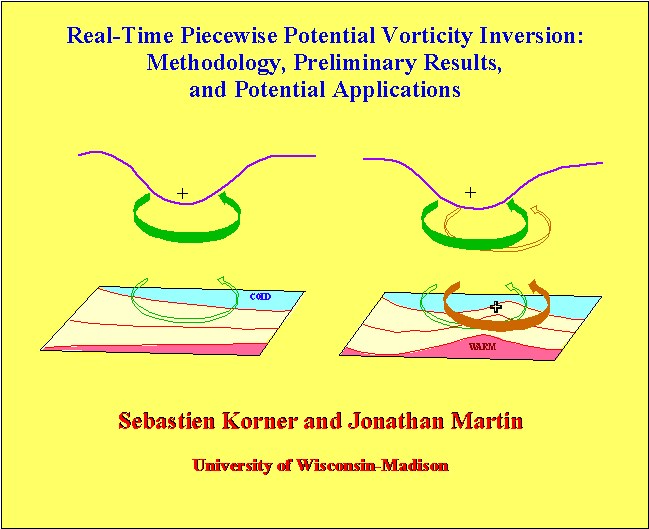